
Home › Forums › A SECURITY AND NEWS FORUM › Ready for Freddy? SA must prepare for more intense weather events
- This topic is empty.
Viewing 1 post (of 1 total)
-
AuthorPosts
-
2023-02-24 at 15:27 #394889
 Nat QuinnKeymaster
As Tropical Cyclone Freddy hits Mozambique, halting on the border of Limpopo this weekend and probably causing heavy rainfall, it’s an important reminder that South Africa needs adequate community-based systems in place to respond to weather events, which are increasing in intensity.
‘An impact is controlled by the readiness of the people to safeguard lives and property,” said the senior manager for disaster risk reduction at the SA Weather Service (Saws), Tshepho Ngobeni.
“So when the tropical cyclone is coming — although the path might change — we inform people way in advance, so it’s easier for them to evacuate.”
Last weekend, the weather service saw that Freddy — which they had been monitoring in the southwest Indian Ocean region for about a week — had become a very intense tropical cyclone (equivalent to a Category 5 hurricane) and would be making its way westwards.
Saws began sending alerts early this week that Freddy was approaching, first passing over Madagascar, before hitting Mozambique and Zimbabwe, which is likely to cause heavy rainfall and flooding in Limpopo and parts of Mpumalanga this weekend.
“Generally, the tropical cyclone will be a system that is expected to cause serious devastation, especially when coming to properties and roads, as you cannot control [movement],” Ngobeni told Our Burning Planet.
But in terms of safeguarding people, tropical cyclones can be prepared for, as meteorologists can see them coming up to two weeks in advance.
“This is a very wide broad system on the ground, the only thing that usually becomes unpredictable is the path, but you know the system is there,” said Ngobeni.
SAWS announced that Freddy made landfall along the eastern coastline of Madagascar, just north of Mananjary, on Tuesday evening, at around 7.3opm.
Saws reported it was a relatively compact storm, a low-end Category 2 tropical cyclone just before making landfall, with winds of 150km/h and gusts up to 180km/h.
Saws explained that cyclones lose speed as they move over land, so Freddy was downgraded to an overland depression on Tuesday evening. But it is expected to have regained its strength as it moved over the Mozambique Channel and to have reached near tropical cyclone status on Thursday as it headed to southern Mozambique, where it is set to make landfall just north of Vilanculos on Friday morning.
Francois Engelbrecht, a professor of climatology and the director of the Global Change Institute at Wits University, told Our Burning Planet that when Freddy passed over Madagascar it was a Category 3 hurricane, and by the time it reaches Mozambique, it will probably be a significant tropical cyclone.
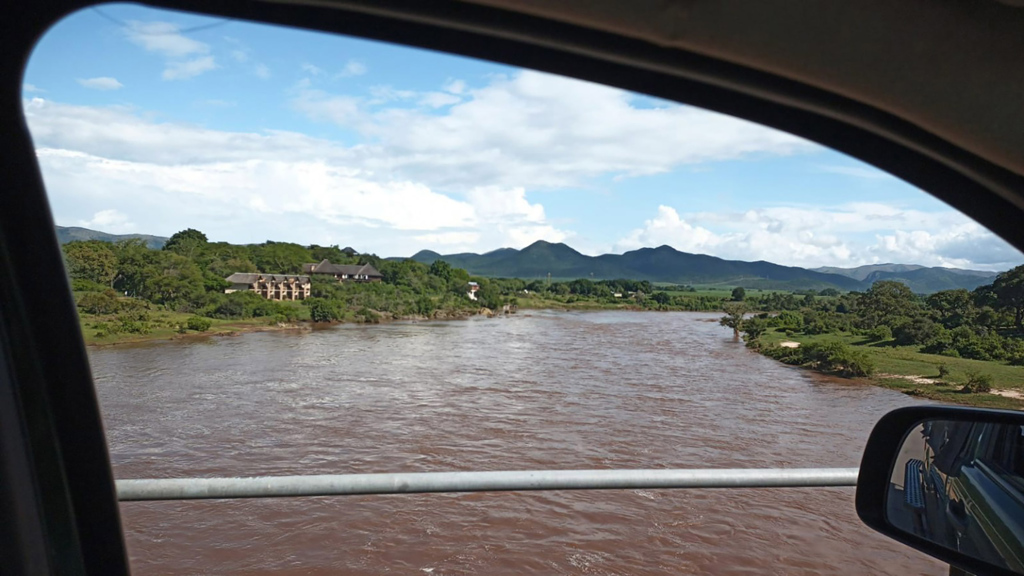
The Crocodile River at Malelane in Mpumalanga, 19 February 2023. (Photo: Mark Fox)
While Freddy will not pass directly over South Africa, Saws expects it will affect the northeastern parts of the country from early on Saturday, 25 February until Monday, 27 February, especially the Lowveld and escarpment areas of Limpopo (Vhembe and Mopani) and to a slightly lesser extent, Ehlanzeni in Mpumalanga.
Ngobeni explained that tropical cyclones are, “relatively small, intensely developed low-pressure cells that usually occur over warm oceans”.
“Their diameter can range between 200 and 2,000km. They are characterised by a warm centre, very steep pressure gradients, strong cyclonic winds near the Earth’s surface and a maximum wind speed exceeding 110km/h.”
Destruction in its wake
As Freddy is passing over Mozambique and will be semi-stationary along the northeastern border of SA for a few days, Saws projects it’s possible that very heavy rainfall in the order of 200 to 400mm could occur, which may result in widespread flooding.
Ngobeni explained that while the cyclone is not passing directly over us, “because of our close proximity to the outer edge of the tropical cyclone, that’s when we’ll get this rainfall”.
“Tropical cyclones are always accompanied by torrential rain,” said Ngobeni during a media briefing at the National Press Club on Thursday.
“A single storm may yield up to 3,000mm of rain. Heavy rains sometimes occur many days after landfall and are also very destructive. They may give rise to floods. Strong winds also occur as a result of the steep pressure gradient.
“The strongest winds occur near the leading edge or in front of the storm. The destruction associated with tropical cyclones results not only from the force of the wind, but also from the storm surge and the waves it generates.”
Engelbrecht explained that as the cyclone is going to move slightly southwestward after hitting land it will head toward the northeastern corner of Limpopo.
“That’s a very slow movement in 24 hours from Vilanculos to that location just outside the border of South Africa,” said Engelbrecht, “and that slow movement is dangerous for us because it means this storm has the potential to dump a lot of rainfall over these areas that it will be lingering over.”
As this is occurring after the significant flooding over the Lowveld and escarpment areas (such as the Kruger National Park) in the last few weeks, Saws warned this “may be catastrophic and cause prolonged and severe impacts”.
Disaster management
Saws is the authority when it comes to issuing weather warnings, as mandated by the South African Weather Service Act and it briefed the National Joint Flood Coordination Committee on Wednesday.
“We advise people accordingly in terms of impeding weather that is approaching [and] what will be the possible impacts,” explained Ngobeni. “As a result, they are prepared to take action — because our main aim is to safeguard lives and property.”
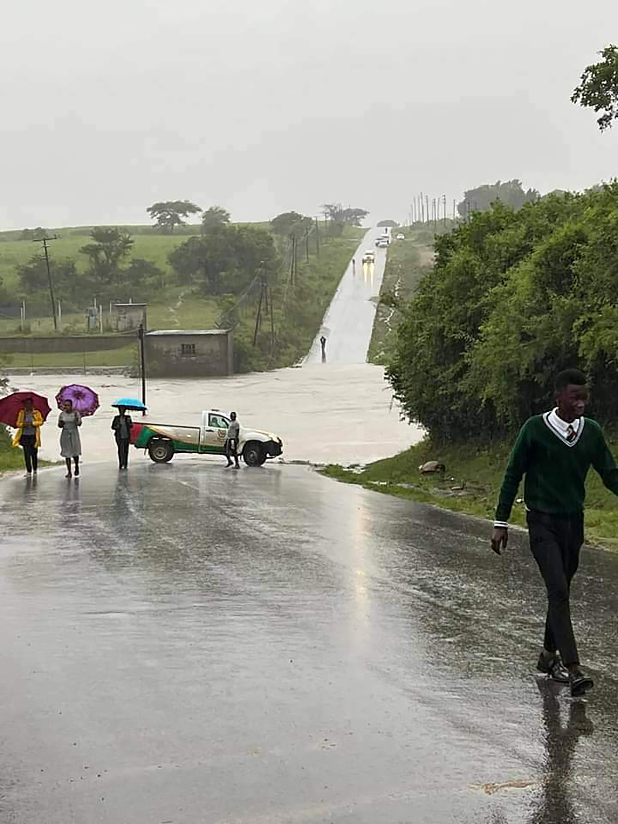
The Vaal River at the Klip River inlet, 19 February 2023. (Photo: Twitter / Rudi Trauernicht / ReenvalSA)
Hitekani Magwedze, the spokesperson for Limpopo’s Department of Cooperative Governance, Human Settlements and Traditional Affairs, told Our Burning Planet that Limpopo’s disaster management team had been in contact with community leaders and councillors to communicate both the alert from the weather service and the plans in place to assist them in case of any danger.
“We currently have 16 teams in both districts made up of Disaster Management officials from district and local municipalities, Fire and Rescue, Emergency Medical Services, Department of Health, Department of Social Development, Sassa, SAPS, SANDF, Department of Transport (Provincial Traffic), Department of Public Services, Eskom, Telkom, communications sections from district and local municipalities, NGOs, ward councillors,” said Magwedze.
“Furthermore, an evacuation plan has been developed to respond to situations as and when they become severe for residents. As part of the response plan, neighbouring district municipalities have been placed on standby in case further resources of any kind are required,” said Magwedze.
Visit Daily Maverick’s home page for more news, analysis and investigations
Ngobeni explained that after Saws provides information, the national and provincial Disaster Management Centres coordinate the assistance needed and make plans, which include the help of the South African Police Service (SAPS) and the South African National Defence Force (SANDF).
SANDF spokesperson Brigadier-General Andries Mahapa told Our Burning Planet, “Since the provincial and national Joint Operation Centres were established we are ready in terms of any disaster.
“So yes, we are ready. We have formed the team. And every morning, there’s meetings, where we sit down and look at the options and plan accordingly.”
Mahapa said operations were already under way, as they were involved last week with a rescue mission airlifting two people who were trapped for three days in Tzaneen, Limpopo.
Helping neighbouring countries
“I think we can expect hundreds of thousands of people in southeastern Mozambique to be directly affected by these floods and the damaging winds around the time of landfall,” said Engelbrecht.
Mahapa said if neighbouring countries called on the SANDF it would help “with whatever capabilities we will have, jointly, we will go and assist”.
Climate change
Cyclones are a part of nature, if humans didn’t exist they would still occur. But what’s important to understand is that there is consensus among the scientific community that cyclones, like other extreme weather events (flooding, heat waves and droughts), are increasing in intensity due to anthropogenic climate change.
Engelbrecht, who was a lead author on a pivotal Intergovernmental Panel on Climate Change report said, “Across the world, we can already detect an increase in the number of Category 4 and 5 hurricanes that is directly attributable to global warming.”
Engelbrecht explained that as we are warming tropical oceans there’s more energy for these systems to develop and there’s also more evaporation from the warmer oceans into the storm systems.
“And when the water vapour eventually condensates to form clouds, it releases so-called latent heat into the storms,” said Engelbrecht.
According to records, Mozambique has never been hit by a Category 5 hurricane. Engelbrecht said that there is published research showing that in the past 20 years, more Category 4 and 5 hurricanes are forming in the southwest Indian Ocean, and when tropical cyclones reach Mozambique they cause more rainfall than in the past.
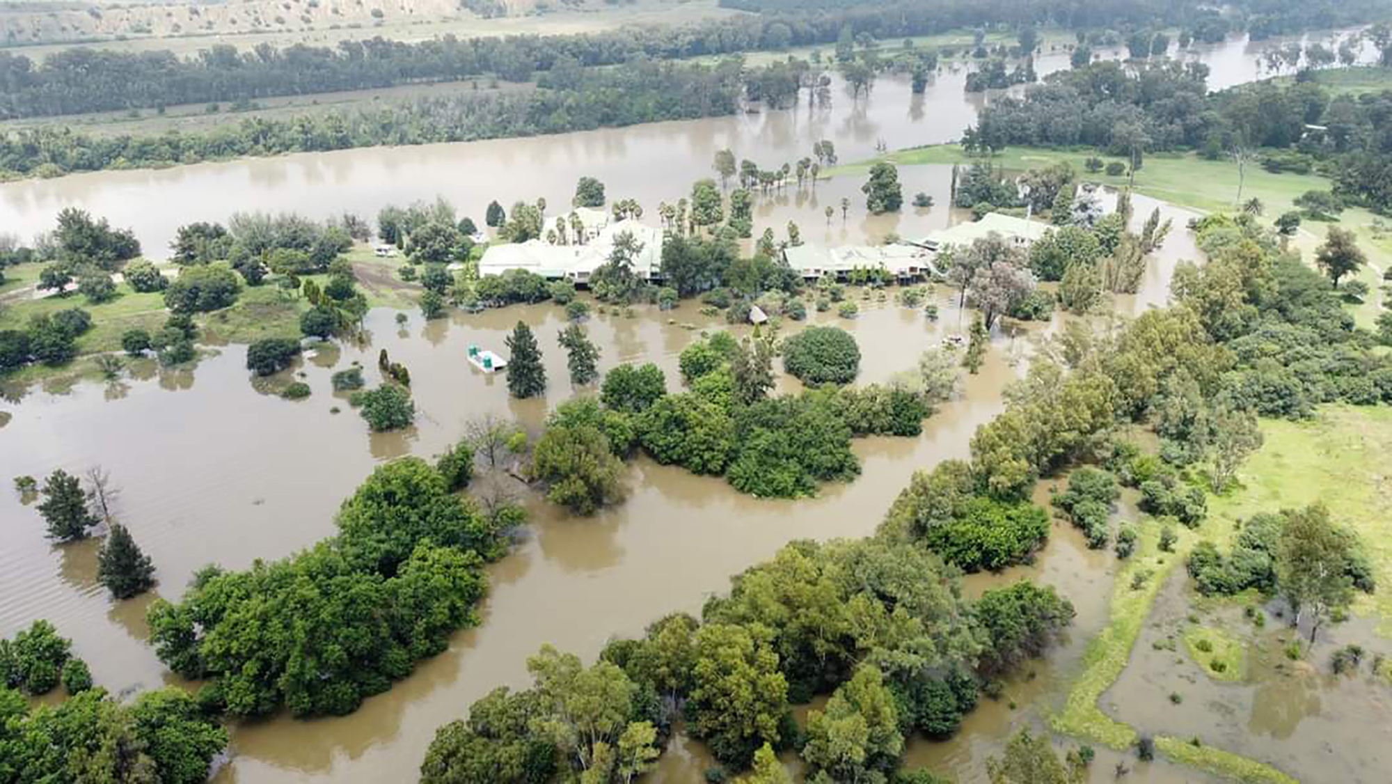
Schoemansdal and Driekoppies near Malelane, Mpumalanga. (Photo: Supplied)
Cyclones today cause about 10% more rainfall than half a century ago in Mozambique, said Engelbrecht, explaining that in a warmer world the cyclones are more intense and carry more water than in the past.
“I think what we need to think about very seriously as southern Africans, is the possibility of the climate system changing to such extent that for the very first time in recorded history, we can have a Category 5 hurricane reaching Mozambique,” said Engelbrecht.
If this were to happen, Engelbrecht said, “we will be in deep trouble” with a high possibility of fatalities.
Engelbrecht said Category 4 or 5 hurricanes result in winds blowing at 200km/h, which no informal housing can withstand, as well as causing flooding and necessitating the evacuation of hundreds of thousands of people. While this level of evacuation already happens in the US, India or Japan, it’s not currently achievable in Mozambique, considering its road infrastructure and level of preparedness.
Engelbrecht said SA can learn a lot from Mozambique, which has more experience with extreme flooding. The tragic example of last year’s KZN floods “demonstrated that SA needs to learn how to evacuate thousands of people out of the path of an approaching flood event”.
Community trust will be needed
“The most vulnerable communities must have the trust in disaster management agencies to act when they get a severe weather warning of a potentially disastrous flood event,” said Engelbrecht, explaining that in the short term, we need to develop better community-based flood early warning systems
Read more in Daily Maverick: “Early warning systems on floods are not enough; climate crisis literacy saves lives – experts”
“But in the longer term, it’s also about giving people safe environments to live in,” said Engelbrecht.
“We can’t quickly fix our immense problems of inequality and poverty. So the reality is that for now, hundreds of thousands of people in our region are living below flood-lines in areas where mudslides occur.”
In the long run, Engelbrecht suggests that we need to make use of international aid mechanisms, under the Paris Agreement, that support climate change adaptation.
“You really have to have trust in communities, you can’t just tell them, move to this region or this piece of land — you must also give water access, transport, so that they can keep competing for jobs.”
Ready for Freddy? SA must prepare for more intense weat… (dailymaverick.co.za)
-
AuthorPosts
Viewing 1 post (of 1 total)
- You must be logged in to reply to this topic.